Search
Content
Media Gallery
Show PageEmergency Contact Numbers
The numbers below are the emergency contact numbers for Subsea Cables and Renewable Energy Structures. These phone numbers relate to each offshore structure and may be used in case of an emergency, or urgent situation.
Show PageEmergency Procedures
Please keep clear of and do not damage subsea cables/structures. You risk the loss of your gear and catch, and international communications can be disrupted. These cables carry high voltages and can be dangerous to life. Many cables have high breaking strains, some over 70 tonnes. Cables will usually lie buried in the seabed, although because the seabed can move, there is no guarantee they will remain in the same place.
Show PageReducing Risks Whilst Fishing
It is essential to be aware of the locations of subsea cables and renewable energy infrastructure, when fishing in the vicinity of such structures. It is essential you have all the information in relation to their positions available to you and the KIS-ORCA project is designed to provide exactly that for all seabed users. Charts, fishing plotter files and an interactive map, showing subsea cables and renewable energy structures surrounding the UK, may be viewed or downloaded, free of charge.
Show PageThe Risks of Fishing near Cables & Renewable Energy Structures
The potential risks associated with the offshore renewable and subsea cable industries come in two distinct categories - surface structures and subsurface structures. Each type of structure may potentially be a risk to fishing activities. The information below describes these hazards, with the subsequent sections explaining the emergency procedures.
Show PageMedia Gallery
Show PageTidal Device Principles
Tidal devices exploit kinetic energy in the tidal flow of water caused by the interaction of the gravitational fields of the earth, moon and sun. Tidal currents are magnified by topographical features, such as headlands, inlets and straits, or sea bed channels. Many of the devices that use these currents are broadly similar to submerged wind turbines. Sea water is around 800 times denser than air but average flow speeds for viable projects are of the order of one fifth of corresponding wind speeds, giving a power density of around 5-10 times. This means that for a tidal device of the same rating as a wind turbine, the rotor will be smaller. Individual tidal devices are unlikely to reach the same rated power as offshore wind turbines; however, as to have sufficient space to deploy such large devices requires development of deeper water sites that generally have less significant tidal flows. EMEC has identified four main types of tidal energy convertors that are outline below.
Show PageWave Device Principles
Waves are created by the interaction of wind with the surface of the sea, sometimes over very long distances. The size of the waves is influenced by wind, the local seabed bathymetry (which can focus or disperse the energy of the waves) and currents. Waves offer a large source of energy which can be converted into electricity by a wave energy converter (WEC). Some wave energy converters have been developed to extract energy from the shoreline, others from waters offshore, some with a hydraulic power take-off system and some with an electrical power take-off system. EMEC has identified six main types of wave energy converter that are outlined below.
Show PageWave & Tidal Devices – Overview
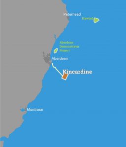
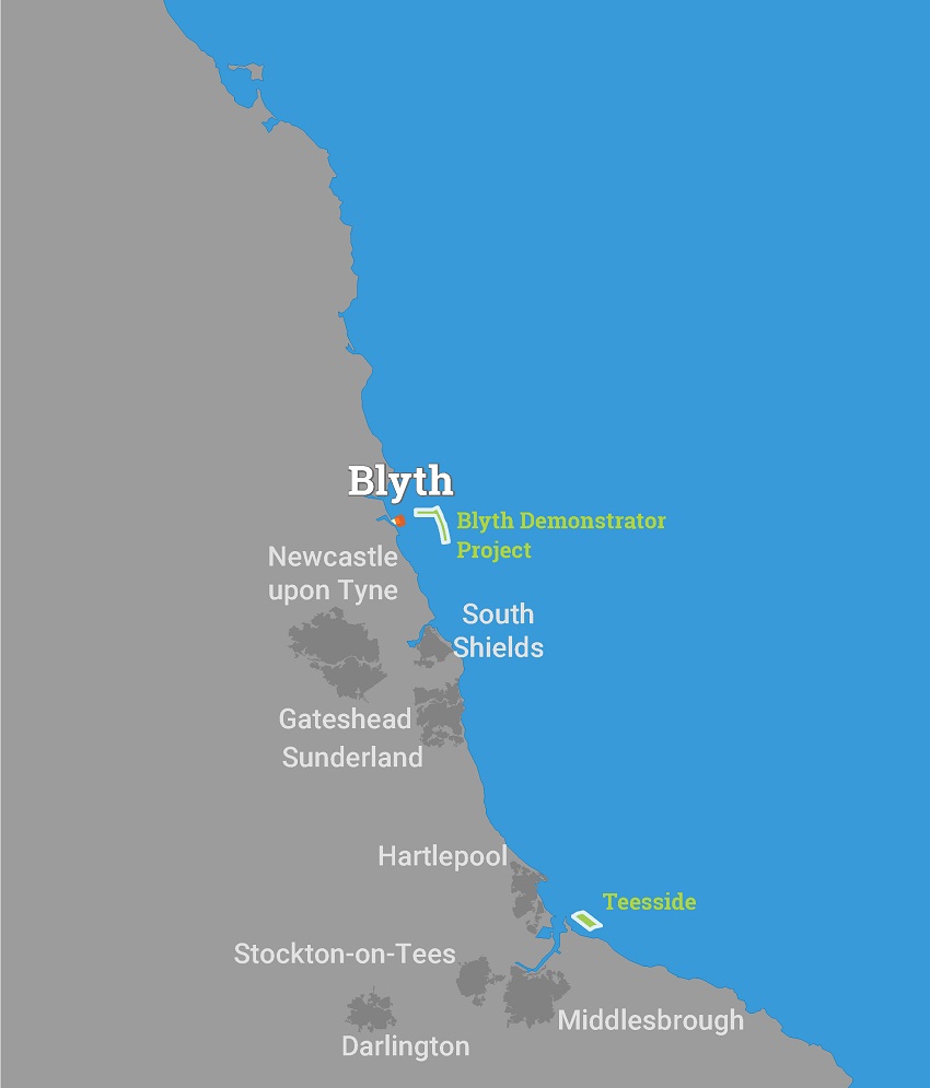
The United Kingdom's wave and tidal stream energy industry is the current global leader, with more installed capacity than the rest of the world combined. Our strength has been built on established British marine engineering skills, the creation of world-first testing facilities and the strength of the energy resource found in UK waters. The UK is proud to have developed the first commercial scale wave and tidal stream projects in 1998 and 2003 respectively but the industry is now on the cusp of commercial viability as we move through the phases of development.
Show PageWind Farms – Installation Methods
Life cycle stages
Lease award and Pre-construction
Once a developer has obtained a lease from the Crown Estate they will start to appraise the zone or lease area. This requires a number of surveys to be completed including boat or aerial based bird and marine mammals surveys, benthic grabs and fish surveys.
Show PageWind Farms – Design of Structures Installed
Offshore wind farms consist of a number of connected elements. These include the turbines, foundations, array cables, offshore substation, export cable and onshore substation and infrastructure. These items are installed using a range of different vessels and then serviced by either smaller crew transfer vessels or helicopters.
Show PageWindfarms - Overview
Offshore wind farms consist of a number of wind turbines which sit on foundations, secured to the seafloor, which produce electricity. This electricity is transmitted to where it is needed through a series of cables and substations. The first offshore wind farm was installed in Denmark in 1991 and the industry has grown rapidly since then with 3.3GW installed across Europe (1.8GW of which is in the UK). China, US, Japan and South Korea have also started to develop offshore wind farms.
Show PageSearch
Show PageTerms & Conditions
Terms and Conditions - KIS-ORCA Website This website, www.kis-orca.eu, ("the Site") is provided to you ("you" meaning any person, firm, partnership, corporate body or any other legal person accessing or otherwise using, or benefitting from the use of, this Site) by the Kingfisher Division of Seafish, ESCA and its Members. Data which is provided via this Site, including Plotter Data, is provided free of charge. Kingfisher Information Services and ESCA DO NOT verify data provided on the Site, including Plotter Data. Please read these Terms carefully before using this Site: 1 AUTHORITY AND LICENCE FOR USE OF THE SITE 1.1 In making use of the Site, you agree to be bound by these Terms which form the sole agreement between you as user of the Site and us ("Agreement"). 1.2 If you do not agree to be bound by these Terms, you should not use the Site. 1.3 You acknowledge that your use of the Site: 1.3.1 may be limited at any time by us; and 1.3.2 may be suspended or terminated at any time by us. 2 DISCLAIMER 2.1 We give you no warranty or assurance, except as set out in Condition 6 (Our Obligations). We declare and you acknowledge that all implied warranties and conditions are excluded to the maximum extent permitted by law. 2.2 We are not responsible for any: 2.2.1 typographical errors or omissions on the Site; 2.2.2 data, information, text, music, sound, photos or graphics or other material ("Content") that you may have access to as part of, or through your use of the Site, including, but not limited to, other websites that you may access via links provided on our Site; or 2.2.3 Content you may be exposed to through use of the Site that you may find offensive, indecent or objectionable. 2.3 We do not warrant that the Content of this Site is accurate, complete, reliable, current or error-free. 3 LIABILITY 3.1 In respect of use of Plotter Data, we shall have no liability whatsoever to you where the Plotter Data: 3.1.1 as provided to us by any data provider or originator is erroneous, inaccurate or in an incomplete form and such fact is not known to us; 3.1.2 is uploaded to any fishing plotter incorrectly or in an incomplete form; 3.1.3 is not read in conjunction with the Kingfisher Fortnightly Bulletin or any other updates, whether in paper or digital form; 3.1.4 is erroneously interpreted by you or utilised by you in a negligent or reckless manner, or for a purpose for which it was not intended or designed. 4 PROPRIETARY RIGHTS 4.1 You acknowledge and agree that we own all copyright and other rights in and to the content of the Site. 4.2 You agree that you will not remove, obscure or alter any proprietary rights notices (including copyright and trade mark notices) which may be affixed to or contained within the Site. 4.3 You agree that you will not use any data from this site for commercial gain without obtaining permission from KIS-ORCA. 5 YOUR OBLIGATIONS 5.1 You will take reasonable steps to ensure that you comply with these Terms and do not: 5.1.1 engage in any activity that interferes with, or disrupts the operation of, the Site; 5.1.2 access or attempt to access any element of the Site by any means other than through the interface that we provide, unless expressly authorised by us; 5.1.3 reproduce, duplicate, copy, sell, trade or resell the facilities provided on the Site, unless expressly authorised by us; 5.1.4 purport to transfer or otherwise dispose of your rights under these Terms. 5.2 By submitting your personal information to us you agree to our collection, use and disclosure of such information in accordance with our privacy policy set out in Condition 7. 6 OUR OBLIGATIONS 6.1 We will take reasonable steps to ensure that the Site supplied is virus-free. 6.2 We shall use our best endeavours to ensure that access and use of the Site is not interrupted by any event within our control. 7 PRIVACY POLICY 7.1 You acknowledge and agree that: 7.1.1 we collect information about you and your use of this Site, together with any details that you may need to provide for access to, or use of, the Site; 7.1.2 we monitor user traffic patterns and Site use. This may be done through the use of cookies; 7.1.3 we use and disclose information in aggregate (so that no individual users are identified) for strategic development purposes. 7.2 We will never pass personal data to anyone else, except to any successor in title to our business and suppliers that may process data on our behalf in the United Kingdom and abroad. 8 TERMINATION 8.1 This Agreement will terminate if you or we are in material breach of any of its terms and if the breach is not remedied within the period of twenty working days after written notice of it has been given to the party in breach. 8.2 On termination of this Agreement for any reason: 8.2.1 all licences granted hereunder shall immediately terminate; and 8.2.2 termination shall not affect or prejudice the accrued rights of the parties as at termination, or the continuation after termination of any provision expressly stated to survive or implicitly surviving termination. 9 MISCELLANEOUS 9.1 This Agreement is not intended to benefit anyone other than the parties to it and, in particular, no term of this Agreement shall be enforceable under the Contracts (Rights of Third Parties) Act 1999 by a third party. 9.2 If any provision (or part of a provision) of this Agreement is found by any court or administrative body of competent jurisdiction to be invalid, unenforceable or illegal, the other provisions shall remain in force. 9.3 Each of the parties acknowledges and agrees that in entering into this Agreement it does not rely on, and shall have no remedy in respect of, any statement, representation, warranty or understanding (whether negligently made or not) of any person (whether party to this Agreement or not) other than as expressly set out in this Agreement. The only remedy available to it for breach of the Agreement shall be for breach of contract under the terms of this Agreement. End Show PageContact
Show PageSitemap
Show PagePrivacy
KIS-ORCA.eu does not store any information that would, on its own, allow us to identify individual users of this service without their permission. Any cookies that may be used by this website are used either solely on a per session basis or to maintain user preferences. When users enter the KIS-ORCA website, their computers will automatically be issued with 'cookies'. Cookies are text files which identify users' computers to servers. The website then creates "session" cookies to store some of the preferences of users moving around the website, e.g. retaining a text-only preference. Cookies in themselves do not identify individual users, but identify only the computer used and they are deleted on departure from the website. Many websites do this to track traffic flows, whenever users visit those websites. The KIS-ORCA website uses third-party cookies to measure use of the website including number of visitors and how frequently pages are viewed. This helps to determine what is popular and can influence future content and development. For this purpose, KIS-ORCA uses Google Analytics to measure and analyse usage of the website. The information collected will include IP Address, pages visited, browser type and operating system. The data will not be used to identify any user personally. Users have the opportunity to set their computers to accept all cookies, to notify them when a cookie is issued, or not to receive cookies at any time. The last of these means that certain personalised services cannot then be provided to that user. This privacy statement only covers the KIS-ORCA website at www.kis-orca.eu This statement does not cover links within this site to other websites. Show PageAccessibility
The KIS-ORCA partners are committed to producing websites and web resources that can be accessed by all its visitors. We are always keen to hear about ways we can improve the services we provide. If you are having any difficulties using this website, please contact kingfisher@seafish.co.uk Many web browsers have accessibility features, which help you use the web in the way that best suits you. We recommend you select the browser which best suits your needs. You may also need to configure your operating sytem to tailor its accessibility features to your needs. Show PageThe Importance of Renewable Energy Structures
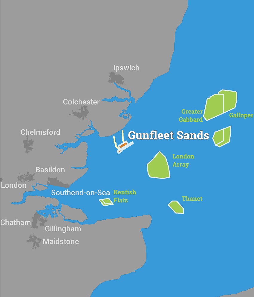
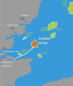
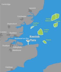
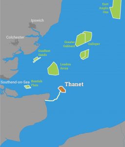
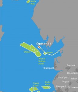
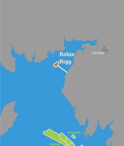
The UK is the world leader in offshore renewables. We have more projects installed, more in construction and more in development than any other country in the world.
Show PageMedia Gallery
Show PageThe Future of Subsea Cables
Subsea telecommunication cables have a very long history. Since the installation of the world's first submarine cable across the Dover Strait in 1850, Subsea cables have been essential to the worlds communications infrastructure.
Show PageSubmarine Cable Maintenance
Under a Cable Maintenance Agreement and on notification from a Maintenance Authority, a cable repair ship operator will mobilise one of its vessels to conduct a repair on a subsea cable. The maintenance authority will provide an estimated position of the cable fault based on tests carried out from the cable Terminal Stations located either end of the marine cable. Permitting, Charting, and existing cable information is assessed prior to the vessel departing.
Show PageMaintenance / Repair Operations
Submarine cables are very reliable, however, there are occasions when a repair to a cable becomes necessary.
Show PageCable Burial
At the planning and installation phase of a submarine cable project one of the most effective methods of protecting a submarine cable from damage caused by external aggression is to bury the cable, usually with a sea plough.
Show PageInstallation Procedures and Methods
Selection of provisional route
Once the requirement for a cable system has been identified and funds raised to build it, the first thing which happens is that a cable manufacturer and installer is contracted by the cable system parties.
Show PageDesign
Modern Fibre optic cables can carry many millions of telephone calls, together with huge amounts of video and internet data. Approximately 95% of the world's telecommunication requirements are met by submarine cables. Cables are used because of their high reliability, capacity and security. Cables have an insignificant delay compared to satellite and are most cost-effective on major routes, hence communications costs are cheaper than satellites.
Show PageAbout
The KIS-ORCA Project The Kingfisher Information Service - Offshore Renewable & Cable Awareness project (KIS-ORCA) is a joint initiative between the European Subsea Cables Association (ESCA) and the Kingfisher Information Service of Seafish. ESCA membership represents much of the subsea telecommunications and offshore renewable energy industry and they work with industry bodies like Renewable UK who recognise the benefit and value of the KIS-ORCA project.
 The aim of the KIS-ORCA project is to provide fishermen with accurate, up to date and free information relating to subsea cables and offshore renewable energy structures across Europe.
KIS-ORCA information is available to fishermen in the following formats:
Fishing Plotter Files
Supplied on USB stick, all the KIS-ORCA data is available to fishermen in the most popular fishing plotter system formats and is updated annually. These files are also available to download from here.
Awareness Charts
Awareness charts are produced for key KIS-ORCA data areas. There are six charts surrounding the UK and localised charts for each constructed wind farm. These are available to download from here.
www.KIS-ORCA.eu
This interactive website allows fishermen to view subsea cable and renewable energy structures on an interactive map, download the latest data and ensure they are up-to-date with the very latest offshore activity news. The website has been produced primarily for Fishing Safety, although also gives fishermen an insight into the offshore industries they share the seabed with.
Show Page
The aim of the KIS-ORCA project is to provide fishermen with accurate, up to date and free information relating to subsea cables and offshore renewable energy structures across Europe.
KIS-ORCA information is available to fishermen in the following formats:
Fishing Plotter Files
Supplied on USB stick, all the KIS-ORCA data is available to fishermen in the most popular fishing plotter system formats and is updated annually. These files are also available to download from here.
Awareness Charts
Awareness charts are produced for key KIS-ORCA data areas. There are six charts surrounding the UK and localised charts for each constructed wind farm. These are available to download from here.
www.KIS-ORCA.eu
This interactive website allows fishermen to view subsea cable and renewable energy structures on an interactive map, download the latest data and ensure they are up-to-date with the very latest offshore activity news. The website has been produced primarily for Fishing Safety, although also gives fishermen an insight into the offshore industries they share the seabed with.
Show Page
Downloads
Show PageNews
Show PageSafety
Offshore windfarms and subsea cables are increasing in number around the shores of the UK and the potential risks to fishermen, associated with these structures, need to be recognised and managed in a responsible way.
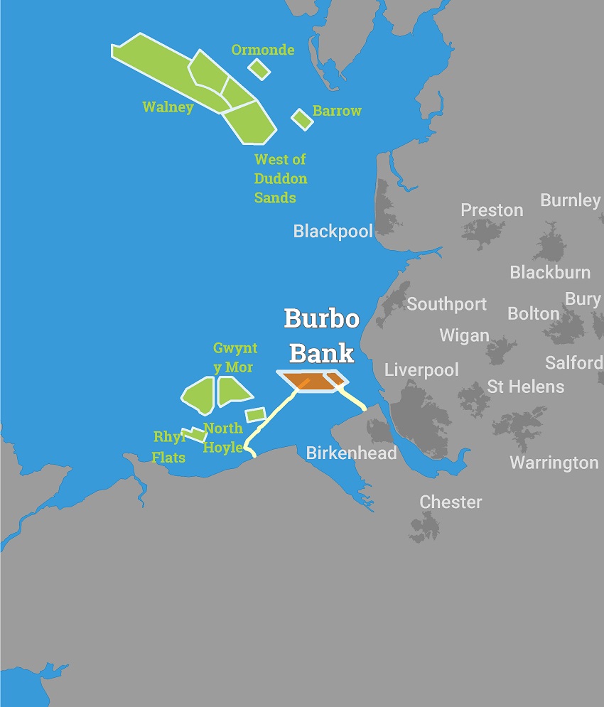
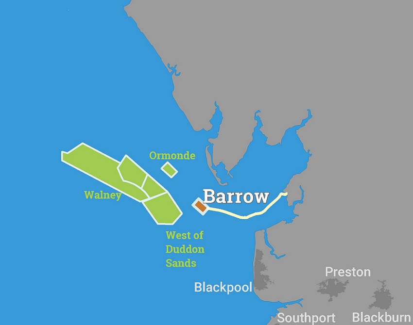
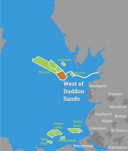
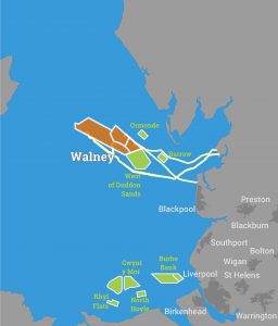
Show PageRenewable Energy
This section contains information relating to Renewable Energy Structures, from design to installation, maintenance to future trends.
Show PageSubsea Cables
This section contains information relating to Subsea Telecoms and Power Cables, from design to installation, maintenance to future trends.
Show PageHomepage
Show PageMap
Show PageDownloads

News
Survey - Sofia Offshore Wind Farm
Fugro are due to commence Offshore Site Investigations along the export cable corridor and turbine array of the Sofia Offshore Wind Farm (SOWF), from the 28th March until July 2020.
Fugro will be undertaking Geotechnical Investigations along the SOWF export cable corridor. In the previous bulletin the start date was anticipated to be 13th March for the Despina. This has been delayed due to weather, but the Despina is planned to be on site before the end of March, provisionally around the 28th March. Works undertaken by the Despina are anticipated to take a month to complete, dependent on weather conditions.
Due to the Despina having limited manoeuvrability whist working in DP mode, it is requested that all vessels operating within this area maintain a safe operational distance, in line with standard procedures i.e. a C.P.A of 500 m, which is included in the survey area buffer of 2,000 m (coordinates below).
Fugro will continue geophysical operations along the export cable corridor and within the offshore turbine array using the Fugro Venturer and the Fugro Pioneer, with works expected to commence at the start of April 2020 and continue through July 2020. Vessels engaged in geophysical survey operations will deploy survey equipment behind the stern of a vessel and will require a large turning area, as detailed within the relevant Notices to Mariners (NTM’s).
Fugro requests a minimum of a 2000m safety zone during geophysical survey operations and all vessels operational in the vicinity should pass at a decreased speed to reduce vessel wash.
The geotechnical vessel ‘Despina’ and geophysical survey vessels will be undertaking survey operations on a 24 hour basis, with the guard vessel ‘Margaret Mary’ providing additional support where necessary. All vessels can be contacted on VHF channel 16 throughout the works for any further information.
The following vessels will be operational on site during these works
|
Type of Vessel |
Vessel Name |
Call Sign |
MMSI Number |
| Geotechnical Survey Vessel | Despina | LAKW7 | 259027000 |
| Geophysical Survey Vessel | Fugro Venturer | C6CG3 |
311000463 |
| Geophysical Survey Vessel | Fugro Pioneer | CBH3 | 311000262 |
|
Guard Vessel |
Margaret Mary |
MGNM6 |
232025575 |
For general enquiries related to Sofia Offshore Wind Farm you can e-mail comms_sofia@innogy.com or telephone: 03301 229670. Further contact details for the Fugro Project Manager and Project Fisheries Liaison Officer are detailed below.
For further information: Sally Dalrymple, Fugro, Tel: +44 7917 058751, email: s.dalrymple@fugro.com;
Nigel Proctor (FLO) Precision Marine Survey Ltd Tel: +44 7702 730891, email n.proctor@precisionmarine.co.uk
See detailed map on our bulletin websiteLandfall survey for Dogger Bank (A&B) Wind Farms
Over water survey investigations are planned from 31 March 2020 until 15 May 2020 (weather dependent). The investigation will involve multiple vessels across the site.
Fugro has been contracted to provide a Marine Ground Investigation for SSE, approximately 8km South of Bridlington for a proposed cable landfall.
The fieldwork consists of 3 Work Elements:
- Work Element 1 – Geophysical Clearance Survey of the cable landfall and nearshore area. 31st March until 23rd April
- Work Element 2 – Nearshore Geotechnical borehole drilling from a jack up barge. Acquisition of geotechnical data at 5 or 6 locations along the cable landfall route. 23rd April until 1st May
- Work Element 3 – Subsurface Geophysical Survey. Acquisition of sub-seabed geophysical information across the cable landfall route. 4th May until 14th May
Work Element 1
- The Geophysical Clearance Survey will be performed by the Fugro Seeker, a 12m LOA (Length Overall) purpose-built survey vessel.
- The vessel will be mobilised in, and all operations and surveys run from, Scarborough.
- A transit route to site of ~26 nautical miles.
- This Work Element is expected to take approximately 5 days (not including weather delays).
Work Element 2
- The Nearshore geotechnical site investigation shall be complete from the Haven Seariser 4, a jack up barge of 29m LOA.
- The proposed site investigations are scheduled along the cable landfall route
- This Work Element is expected to take approximately 10 days (not including weather delays).
- Operations will continue on a 24hr basis.
- The Jack-up barge will be lit to allow night time operations and display RED_WHITE_RED lighting/shapes to indicate that it is a vessel restricted in her ability to manoeuvre.
- Vessels should keep clear of the jack-up barge at all times and are requested to not approach within 50m.
- Crew will transfer twice a day in the support RHIB, from the jack up barge directly to Bridlington Harbour.
Work Element 3
- The Subsurface Geophysical Survey will be performed from 2no. 9m LOA covered RHIBs.
- This Work Element is expected to take approximately 13 days (not including weather delays).
- The RHIBs will transfer to site daily from Bridlington Harbour.
Survey - Hornsea Two
A Benthic survey for the Hornsea Project Two Offshore Wind Farm using the vessel "DSV Curtis Marshal Callsign: 2HWN3" from 24th March until end April 2020.
Ørsted will be carrying out benthic surveys using the DSV Curtis Marshall Call Sign: 2HWN3 in the Hornsea Project Two wind farm array.
The surveys are expected to commence on or shortly after 24th March 2020 and may last until the end of April 2020. The exact survey dates are dependent on weather and work progress. When the works are complete, this Notice will be updated and re-issued.
The vessel will be towing a subsea camera system and may be undertaking grab sampling. As such, the vessel will have limited manoeuvrability and it is requested that all vessels operating near the vessels maintain a safe distance (at least 500m) and pass all vessels at minimum speed.
See detailed map on our bulletin websiteRig - Valaris 72
Oil & gas rigs are protected by a 500m safety zone and some may have anchors extending beyond this zone.
Show MoreRig - Energy Endeavour
Oil & gas rigs are protected by a 500m safety zone and some may have anchors extending beyond this zone.
Show MorePipeline Flushing and Riser Deccommissioning - Huntington Field
Please note that Premier Oil’s project to flush and disconnect the Huntington field subsea infrastructure and removal of associated risers in relation to the float-off of the (Teekay owned and operated)
Voyager Spirit FPSO will be undertaken during the period of 5th April 2020 to 31st December 2020.
The earliest start date for operations to commence is 5th April. The flushing operations are expected to last 11 days. Disconnection activities will carried out between 7th and 24th May. Both flushing and disconnection works will be undertaken from the Seven Falcon DSV.
The risers will be recovered at a later date, post FPSO float-off.
See detailed map on our bulletin websiteSurvey - (Ref:1072)
10 day survey, 6th April - 30th September 2020, vessel "TBC"
| Company | Vessels |
Towed Cable Length & Depth |
Duration | Survey Block |
| CNOOC Petroleum Europe Ltd |
TBC
|
1200m 3m |
06/04/2020 - 30/09/2020 For 10 Days |
14/26, 20/1 |
Survey - Western Isles Cable Inspections (Central Element)
Briggs Marine Contractors (on behalf of SHEPD) will be undertaking hydrographic surveys to a number of subsea electricity cables within a 1km wide corridor. From 2nd April 2020 for 28 Days
The work will utilise the inshore survey vessel Mersey Guardian Call Sign: 2FGL4 and offshore survey vessel Topaz Tiamat Call Sign:V7A2125 for the operations.
See detailed map on our bulletin websiteSurvey - Western Isles Cable Inspection (Southern Element)
Briggs Marine Contractors (on behalf of SHEPD) will be undertaking hydrographic surveys to a number of subsea electricity cables within a 1km wide corridor. From 2 April 2020 for 28 Days
The work will utilise the inshore survey vessel Mersey Guardian Call Sign: 2FGL4 and offshore survey vessel Topaz Tiamat Call Sign:V7A2125 for the operations.
See detailed map on our bulletin websiteSurvey - Western Isles Cable Inspections (Northern Element)
Briggs Marine Contractors (on behalf of SHEPD) will be undertaking hydrographic surveys to a number of subsea electricity cables within a 1km wide corridor. From 2 April 2020 for 28 Days
The work will utilise the inshore survey vessel Mersey Guardian Call Sign: 2FGL4 and offshore survey vessel Topaz Tiamat Call Sign:V7A2125 for the operations.
See detailed map on our bulletin websiteUXO Survey (Neart na Gaoithe Wind Farm)
A UXO Survey is continuing along the wind farm export cable route (until 18 May 2020) using the vessel "Glomar Wave" (call sign: 3FX4)
| Vessels |
Survey Area |
Duration |
|
Potential UXO Inspection survey: Glomar Wave 3FXF4
Guard vessel: Artemis MVIX5 Tranquillity S MJUH9 or Seagull MVBO2
|
Cable Route 56° 14.349' N 2° 18.237' W 55° 57.734' N 2° 22.472' W 55° 57.603' N 2° 23.199' W 55° 57.757' N 2° 23.301' W 55° 57.866' N 2° 22.729' W 56° 00.990' N 2° 21.938' W 56° 01.017' N 2° 22.262' W 56° 02.498' N 2° 21.882' W 56° 02.475' N 2° 21.561' W 56° 14.546' N 2° 18.479' W |
02/12/2019 - 18/05/2020 |
Construction of Wind Farm (Neart na Gaothie)
Activities are continuing related to the development of the Neart na Gaothie wind farm.
Survey
1 Month Survey, due to commence on 17 March 2020 within the bundary of the wind farm using the vessel "Fugro Mercator" (call sign: C6DU5).
Guard vessel: Artemis (MVIX5), Tranquillity S, (MJUH9) or Seagull (MVBO2).
UXO
During a UXO inspection survey within the boundaries of the Neart na Gaoithe Offshore Wind Farm Site and Cable Route, a number of confirmed UXO (cUXO) targets have been identified so far. The cUXO target locations identified between 12 December 2019 and 7 January 2020 are provided in the table below.
A 50m exclusion zone is requested at each of these locations.
| Latitude | Longitude | Description | |||
|
|
|
Buoyage
Five special markers are now in position:
| Name | Location |
|
SP 1 - Special Mark - Fl Y 5s light character |
56°18.180'N 02°12.075'W |
|
SP 2 - Special Mark - Fl Y 5s light character |
56°15.643'N 02°09.329'W |
|
SP 3 - Special Mark - Fl Y 5s light character |
56°12.294'N 02°15.796'W |
|
SP 4 - Special Mark - Fl Y 5s light character |
56°14.038'N 02°18.975'W |
|
SP 5 - Special Mark - Fl Y 5s light character |
56°18.924'N 02°18.951'W |
Four cardinal buoys are due to be deployed the week commencing 16th March. Planned deployment locations
| Name | Location |
|
NNG - North Cardinal - Quick (Q) white light character |
56°20.425'N 02°14.617'W |
|
NNG - East Cardinal - Q (3) 10 s white light character |
56°14.329'N 02°08.558'W |
|
NNG - South Cardinal - Q (6) + Long (L) FL 15 s white light character |
56°12.294'N 02°09.760'W |
|
NNG - West Cardinal - Q (9) 15 s white light character |
56°17.057'N 02°21.084'W |
A steel chain will be connected to each marker buoy, and the chain will be present through the water column, connected to an anchor placed on the seabed.
See detailed map on our bulletin websiteConstruction of Wind Farm (Triton Knoll)
Activities are continuing related to the development of the Triton Knoll wind farm. For background information visit: http://www.tritonknoll.co.uk/
Vessels will be operating as follows:
|
Vessel Name |
Type |
Call Sign |
MMSI |
IMO |
Operating Port |
Commence Date |
|
Sorrento |
Guard Vessel |
SXLE |
235087639 |
N/A |
Grimsby |
28/12/19 |
|
Precision 1 |
Guard Vessel |
2FCD2 |
235089165 |
N/A |
Hull |
28/12/19 |
|
Seacat Intrepid |
Crew Transfer |
2HWU6 |
235107284 |
N/A |
Grimsby |
01/01/20 |
|
Seaway Strashnov |
Heavy Lift Vessel |
5BNL2 |
212905000 |
9452701 |
Rotterdam |
01/01/20 |
|
Manta |
AHTS |
ORKJ |
205340000 |
9261487 |
Rotterdam |
01/01/20 |
|
Seraya |
AHTS |
9HA4875 |
248942000 |
9662368 |
Rotterdam |
01/01/20 |
| Esvagt Froude | Service Operations Vessel | OWWN2 | 219590000 | 9703461 | Grimsby | 02/02/20 |
| Esvagt Wind 1 | High Speed Craft | XPE6305 | 219019815 | N/A | Esvagt Froude | 02/02/20 |
|
Boka Falcon |
Boulder Clearance |
HP9176 |
370782000 |
9448401 |
Rotterdam |
13/02/20 |
| Dalby Don | Crew Transfer Vessel | 2IMZ6 | 235111112 | N/A | Grimsby | 18/02/20 |
| Guardian | Survey Vessel | PCFJ | 244750806 | N/A | Grimsby | 18/02/20 |
| Greenbarge 1 | North Sea Barge | N/A | N/A | 32120 | Newcastle | 14/03/20 |
| Centaurus | Towing Vessel for Greenbarge 1 | V2ED3 | 305820000 | 9433755 | Newcastle | 14/03/20 |
| EDT Hercules | Boulder Picking / Mattress Laying | 5BAM4 | 210776000 | 9491422 | Aberdeen | 24/03/20 |
| Terra Plana | Sand Wave Levelling | 5BBX5 | 209396000 | 9788746 | Grimsby | 27/03/20 |
| Greenbarge 3 | North Sea Barge | N/A | N/A | LG7125 | Antwerp | 29/03/20 |
| Centaurus | Towing Vessel for Greenbarge 3 | TBC | TBC | TBC | Antwerp | 31/03/20 |
| Boka Atlantis |
Boulder Clearance / Mattress Installation |
V7SG3 | 538003646 | 9441221 | Vlissingen | 23/03/20 |
| Voe Vanguard |
Pre-Lay Grapnel Run |
MBEN9 | 232008636 | 9809693 | Grimsby | 01/04/20 |
| Zwerver 3 |
Mass Flow Excavation |
PCLQ | 246024000 | 9614878 | Vlissingen | 06/04/20 |
| Thor | Jack Up Vessel | DIAV2 | 218389000 | 9577147 | Vlissingen | 16/04/20 |
| Ndurance |
Cable Installation |
5BVH3 | 09851000 | 9632466 | Rotterdam | 02/05/20 |
All Vessels Can be Contacted Via VHF 16 When Infield
Activities planned for the next 7 days:
- Guard Vessel “Sorrento” continues infield monitoring activities.
- Anchor Handling Vessels “Manta” and “Seraya” support foundation installation with 8 point mooring spread installation / recovery.
- Heavy Lift Vessel “Seaway Strashnov” to continue foundation installation works infield at locations “TK-G09” (OSPW) and then relocate to“TK-F18” (OSPE) for installation works.
- Crew Transfer Vessel “Seacat Intrepid” operating on site as required from Grimsby.
- Boulder clearance vessel “Boka Falcon” carrying out boulder clearance works within the TKOWF boundary.
- Service Operations Vessel “Esvagt Froude” infield supporting construction operations.
- Crew Transfer Vessel “Dalby Don” infield supporting “Boka Falcon” activities.
- Survey Vessel “Guardian” continues pre installation survey operations across the proposed cable locations.
- Towing tug “Centaurus” infield with North Sea Barge “Greenbarge 1” carrying OSPW & OSPE foundation components. Working closely with Seaway Strashnov.
- Anchor Handling Vessel “Afon Wen” infield to carry out interim surveys of the perimeter demarcation buoys.
*** Note ***
Application of Triton Knoll Wind Farm Safety Zones During Construction
The Secretary of State has granted the Application of Safety Zones on the Triton Knoll Wind Farm Project as follows:
- 500m “rolling” safety zones around any structure where construction is being undertaken (as indicated by the presence of construction vessels).
- 50m pre-commissioning safety zones surrounding partial structures or completed structures prior to commissioning.
Buoys
Partrac Ltd. deployed an additional x3 Demarcation Buoys and x1 Metocean Buoy (Figure 1) at the Triton Knoll Offshore Wind Farm (TKOWF) on 24th November 2019 using the vessel THV Galatea operated by Trinity House.
Vessels are requested to leave a wide berth during the installation operations. The buoys will be deployed for a period of two years, and all equipment will be removed at the end of the installation.
South Cardinal buoys TK01 and TK05 described in the table below have been recovered from Triton Knoll Offshore Wind Farm for maintenance by the vessel – “Afon Wen”.
Guard Vessel “Sorrento” has been placed in the general vicinity as a mitigation measure until such a time the buoyage is reinstated.
|
Buoy |
Structure |
Latitude |
Longitude |
Individual Specification |
|
TK01 |
South Cardinal |
53°24.054'N |
000°57.935'E |
Pillar shaped with a south cardinal shaped top mark, exhibiting a Q (6) + L Fl 15s light character (5 nm nominal light range) RECOVERED |
|
TK02 |
Special Mark |
53°24.568'N |
000°54.433'E |
Pillar shaped with a yellow ‘x’ shaped top mark, exhibiting a Fl Y 5s light character (5 nm nominal light range) |
|
TK03 |
Special Mark |
53°26.132'N |
000°50.008'E |
Pillar shaped with a yellow ‘x’ shaped top mark, exhibiting a Fl Y 5s light character (5 nm nominal light range) |
|
TK04 |
Special Mark |
53°27.457'N |
000°45.927'E |
Pillar shaped with a yellow ‘x’ shaped top mark, exhibiting a Fl Y 5s light character (5 nm nominal light range) |
|
TK05 |
South Cardinal |
53°28.859'N |
000°41.181'E |
Pillar shaped with a south cardinal shaped top mark, exhibiting a VQ (6) + L Fl 10s light character (5 nm nominal light range) RECOVERED |
|
TK06 |
Special Mark |
53°30.807'N |
000°41.826'E |
Pillar shaped with a yellow ‘x’ shaped top mark, exhibiting a Fl Y 5s light character (5 nm nominal light range) |
|
TK07 |
North Cardinal |
53°32.196'N |
000°44.248'E |
Pillar shaped with a north cardinal shaped top mark, exhibiting a Very Quick (VQ) light character (5 nm nominal light range) |
|
TK08 |
Special Mark |
53°32.444'N |
000°47.678'E |
Pillar shaped with a yellow ‘x’ shaped top mark, exhibiting a Fl Y 5s light character (5 nm nominal light range |
|
TK09 |
North Cardinal |
53°32.428'N |
000°52.040'E |
Pillar shaped with a north cardinal shaped top mark, exhibiting a Q light character (5 nm nominal light range) |
|
TK10 |
Special Mark |
53°29.595'N |
000°55.306'E |
Pillar shaped with a yellow ‘x’ shaped top mark, exhibiting a Fl Y 5 second (s) light character (5 nm nominal light range) |
|
TK11 |
Special Mark |
53°26.979'N |
000°57.974'E |
Pillar shaped with a yellow ‘x’ shaped top mark, exhibiting a Fl Y 5s light character (5 nm nominal light range) |
|
TK12 |
East Cardinal |
53°24.368'N |
001°00.228'E |
Pillar shaped with an east cardinal shaped top mark, exhibiting a Q (3) 10s light character (5nm nominal light range) |
|
TK13 |
Metocean Buoy |
53°26.002'N |
000°55.091'E |
Triaxys metocean wave and current buoy (South) exhibiting a Fl (5) Y 20s light character (3 nm nominal light range) |
|
TK14 |
Metocean Buoy |
53°30.581'N |
000°47.944'E |
Triaxys metocean wave and current buoy (North) exhibiting a Fl (5) Y 20s light character (3 nm nominal light range) |
See detailed map on our bulletin website
Pipeline Bundles & new template - Snorre Field
Equinor and contractor Subsea 7 will perform a tow operation of two 6.7km long pipeline bundles from the bundle fabrication site in Wester, Wick, Scotland to the Snorre Field in the NCS block 34/4 and 34/7. Bundle tow 19th March complete by 20th March.
The transport and installation of the pipeline bundles will be performed by the main vessel Siem Sprearfish (east bundle) and Seven Arctic (north bundle) + additional support vessels. The East Bundle will be installed between Snorre A, and Snorre template X and Z. The North Bundle will be installed between Snorre template Z, M and N.
The Snorre East Bundle is currently parked due to bad weather in location: KP 370 60°24.908'N 001°38.195'E
North bundle is delayed, not expected to commence tow before 1st week of April.
In addition 2 new templates will be installed at the Snorre Field in the period 01/04/2020 - 01/05/2020 by contractor Deep Ocean with the vessel Edda Freya.
Generalized Tow Route from Wick to Snorre Field
|
Location |
Latitude |
Longitude |
|
Wick |
58°30.487'N |
03°08.066'W |
|
58°24.823'N |
02°24.977'W |
|
|
59°02.655'N |
00°06.246'W |
|
|
59°35.373'N |
00°26.357'E |
|
|
60°06.001'N |
01°01.277'E |
|
|
60°38.125'N |
01°58.685'E |
|
|
60°49.326'N |
02°18.928'E |
|
|
61°03.616'N |
02°25.444'E |
|
|
Snorre Field |
61°31.671'N |
02°07.647'E |
New template installations at Snorre Field
|
Location |
Latitude |
Longitude |
|
Snorre Template N |
61°33.297'N |
02°15.321'E |
|
Snorre Template Z |
61°29.745'N |
02°13.911'E |
Existing template at Snorre Field currently being monitored
|
Location |
Latitude |
Longitude |
|
Snorre Template M |
61°32.160'N |
02°14.718'E |
|
Snorre Template V |
61°29.738'N |
02°08.894'E |
|
Snorre Template W |
61°30.818'N |
02°07.330'E |
|
Snorre Template X |
61°28.936'N |
02°12.273'E |
Please be noted that the templates and bundle towheads, also the ones installed last year will not be over-trawlable until all installation activities are complete in October/November later this year. Equinor marine centre will monitor marine activities at these locations and can be contacted on +47 55 14 32 78 or VHF Ch. 14
See detailed map on our bulletin websiteSurvey - Hornsea Project Four
Hornsea Project Four will be carrying out offshore geophysical surveys from 20 March 2020 (weather dependent) for the proposed Hornsea Project Four Offshore Wind Farm located within the UK Sector of the North Sea, off the coast of East Yorkshire.
Ørsted will be carrying out a geophysical survey with the vessel Geo Ocean IV for the Hornsea Project Four Wind Farm.
A local scout/pilot vessel (Moremma) will also be contracted to reduce any potential interactions with static fishing gear markers.
The operations are planned to commence on or around 20 March 2020 and last approximately 2 weeks. The exact survey dates are dependent on weather and work progress, but the forecasted completion date as of the publication date of this notice is the end of April 2019.
The survey areas will be covered using a full geophysical survey spread including towed equipment which may be up to 400m behind the vessel. It is requested that all vessels operating within the area keep a safe distance (750m) and pass at minimum speed.
Survey Vessel: Geo Ocean IV
Call Sign: LXHD
Sat Phone: +32 (0) 4769 208 75
See detailed map on our bulletin websiteBoulder Clearance - Hornsea Project Two
Boskalis will be carrying out boulder clearance on behalf of Hornsea Project Two along the proposed export cable routes using the Boka Falcon from 22nd March 2020
|
Company Vessel & Call Sign |
Survey Area | Duration | |
|
Orsted Boka Falcon HP9176 Titan Endeavour 2ELT9 |
|
22 nd March 2020 |
See detailed map on our bulletin website
Survey - Sheringham & Dudgeon Offshore Wind Farm
A 60 day survey geophysical survey will be conducted on the proposed Sheringham Shoal and Dudgeon Extension offshore windfarm on the North Norfolk coast
| Company | Vessels |
Area |
Duration | |
|
Equinor ASA |
Ocean Endeavour GAAL
|
|
01/04/2020 For 60 Days |
Survey - West of Oseberg
R/V Petrel Explorer (call sign 5BKK) will start seismic survey West of Oseberg area in the Norwegian sector and cross the border to the UK after few days.
140-180 nodes on the bottom, each one between 4-500 kg, the distance between each 1000-1800m. 90% of the nodes will be on the Norwegian side, 8-10 nodes will be on the border or couple of cables into the UK sector.
| Company | Vessels |
Towed Cable Length & Depth |
Duration |
| Petrel Explorer |
R/V Petrel Explorer 5BKK
|
140-180 nodes 1000- 1800m |
21/03/2020 - 30/04/2020 |
Topsides Dismantlement of the Pickerill A Installation
Due to the current global pandemic the Energy Endeavour will not commence decommissioning works, but will remain positioned at the platform for an indefinite period.
Upon completion of the Hyde Velocity String Works the Energy Endeavour Jack-Up Barge, has now sailed and moved into position at the Pickerill A Platform UKCS 48/11.
See detailed map on our bulletin websiteDecommissioning - Suspended Well Whirlwind 205/21a-5
Petrofac Facilities Management Ltd (PFML) propose to cut and retrieve the wellheads at the Whirlwind well location, located west of Shetland.
The wellhead cutting operation will be carried out using the Helix Seawell LWIV (the vessel uses DP to maintain position).
It is proposed that wellhead cutting operations will begin at the earliest the 15th March 2020 and take around 2-3 days
See detailed map on our bulletin websiteDrilling - Birgitta Field 22/19a
The Maersk Resilient will start a drilling operation in Block 22/19a UKCS from 17th March 2020
| Field | Well | Position | Start/Finish | Duration |
| Birgitta | 22/19a | 57°21.366'N 001°38.196'E | 17/03/2020 | 51 Days |
See detailed map on our bulletin website
Survey - (Ref:1071)
A 6 day survey, expected to start 12 April 2020 with the vessel "Ocean Reliance" (HP6391)
| Company | Vessels |
Towed Cable Length & Depth |
Duration | Survey Block |
| Gardline Ltd |
Ocean Reliance HP6391
|
1200m |
12/04/2020 - 01/04/2021 For 6 Days |
42/3,6 |
Survey - (Ref:1070)
A 6 day survey, expected to start 12 April 2020 with the vessel "Ocean Reliance" (HP6391)
| Company | Vessels |
Towed Cable Length & Depth |
Duration | Survey Block |
| Gardline Ltd |
Ocean Reliance HP6391
|
1200m |
12/04/2020 - 01/04/2021 For 6 Days |
32/28, 42/2,3 |
Development - Catcher Field
Drilling and subsea activities to be undertaken, on behalf of Premier Oil UK Limited at the Catcher Field located in block 28/9a of the UKCS.
Drilling
The Valaris Gorilla VI Mobile Offshore Drilling Unit will mobilise from Dundee Forth Ports 03/04/20 and arrive at Catcher Varadero Drilling Template 56°48.410'N 000° 42.430'E 05/04/20.
The Gorilla VI will remain on location at Varadero Drilling Template until transiting to Catcher North Laverda Drilling Template 56°48.927'N 00°44.087'E circa 02/07/20. The Gorilla VI is then scheduled to remain at Catcher North Laverda until December 2020.
Subsea
- Subsea 7 Skandi Acergy Phase 1 will mobilise 08/05/20 for 1 week for template installation at Catcher North Laverda.
- Skandi Acergy Phase 2 will mobilise 21/05/20 for 2 weeks for umbilical and pipeline installation from Varadero to Catcher North Laverda.
- Subsea rock installation vessel will mobilise 24/06/20 for 1 week to perform rockdumping activities between Varadero and Catcher North Laverda templates.
Diving Support Vessel will mobilise 18/09/20 for 3 weeks to perform template tie-ins at Varadero.
See detailed map on our bulletin websiteCable Repairs - IFA 2 Interconnector Project
Cable works for the IFA2 project are continuing at KP170.3 of IFA2 RPL (50°39.117'N 000°50.855'W)
Cables Repair works of the HVDC bundle in the vicinity of KP170 are continuing.
The Jack up ring Brave Tern will be deploying 2 yellow cable marker buoy approx. 150m apart and from each one a line 15m long with A4 buoys attached. It is expected that one will be placed in the water on 17/18 March 2020 and it is anticipated that they will remain in situ for at least two weeks.
Vessels should pass at a safe speed and distance (approximately 500 metres) from all construction and support vessels. During these works the vessels will have restricted maneuverability as they complete their work scope.
Deployed Guard Vessels will monitor the exposed areas of cable while works progresses and advise of safe distances locally.
See detailed map on our bulletin websiteDropped Drill String - Recovered
UPDATE: All 423ft of Drill-String has now been recovered from the seabed as of 15th March 2020.
423 ft. of drill-string consisting of 142 ft. of 5 ½ inch heavy weight 105 drill pipe and 281 ft. of S-135 drill pipe. The drill pipe is made of iron with a 5 ½ inch diameter and is used for normal drilling of wells.
See detailed map on our bulletin websiteConstruction of wind farm (Moray East)
Due to the construction of the Moray East Offshore Wind Farm, there are several elements to this notice - safety zones; construction schedule; and buoy positions.
For background information about Moray East, please visit: www.morayoffshore.com/moray-east
Safety Zones
Please be advised that the Scottish Ministers have authorised the use of the safety zones during construction and operation of the Moray East Offshore Wind Farm as detailed below.
During construction
- A 500 metre radius around each WTG and OSP where construction works are taking place that include sensitive activities being undertaken by vessels RAM. A maximum of three of such zones is permitted at any one time.
- A 50 metre radius around partially completed WTGs and OSPs where work is not underway and the risk assessments identify a need.
- A 50 metre radius around each completed WTG and OSP prior to commissioning and as required by a risk assessment process.
During major maintenance
- A 500 metre radius around all major maintenance works being undertaken around the WTGs and OSPs. No more than one major maintenance zone is permitted at any one time.
Construction Activities
It is currently anticipated that weather permitting offshore construction works will be carried out on a continuous basis (i.e. 24 hour working, seven days a week) unless notified otherwise.
Please be aware that by virtue of its mode of operation and the equipment deployed, the MV Apollo and the MV Normand Service will be Restricted in their Ability to Manoeuvre as defined under COLREGS (International Regulations for Preventing Collisions at Sea 1972, Rule 3). Masters of vessels are therefore requested to maintain their vessels and gears at a minimum safe distance from these vessels of 500 metres when they are undertaking it work and showing the appropriate shapes and lights. Further Notice to Mariners will be issued as construction progresses.
|
Company, Vessel & Call Sign |
Survey Area |
Survey Area |
Start Timeframe & Duration |
|
GeoSea MV Apollo LXBP |
58°13.261'N 02°34.267'W 58°08.003'N 02°34.182'W 58°03.878'N 02°54.747'W |
58°12.529'N 02°52.563'W 58°19.425'N 02°44.191'W |
1 May 2019 for approximately 11 months |
|
GeoSea MV Normand Service LAFR8 |
As above |
As above |
As above |
|
Kinnaird Marine GV Replenish MASY7 |
As above |
As above |
As above |
|
Kinnaird Marine GV Resolute MLPD5 |
As above |
As above |
As above |
|
Kinnaird Marine GV Ability MDFW3 |
As above |
As above |
As above |
See detailed map on our bulletin website
Survey - (Ref:1067)
A 10 day survey, expected to start 4 April 2020 for 10 Days, with the vessel "Ocean Reliance" (HP6391)
| Company | Vessels |
Towed Cable Length & Depth |
Duration | Survey Block |
| Gardline Ltd |
Ocean Reliance HP6391
|
N/A |
04/04/2020 - 31/05/2020 For 10 Days |
43 |
Tolmount to Easington Pipeline Construction
Saipem Ltd will be performing offshore construction works, including pipelay activities, on behalf of Premier Oil Ltd on the proposed Tolmount Area Development located in block 42/28d of the Southern North Sea, approximately 50km North East of Easington
The works will be performed on the Tolmount to Easington pipeline route which is approximately 48 km in length and is located in the North Sea east of Bridlington. The pipeline will terminate offshore at the Minimum Facilities Platform (MFP) location.
The works will consist of:
- Inshore dredging operations
- Route preparations
- Pipelay and associated support and completion activities
- Subsea tie-in activities at the platform end pipeline termination
Two discrete operating areas are identified as follows;
- Inshore Dredging Operations Area
- Pipelay Operations Area
Operations will be conducted on a twenty-four (24) hour per day basis, seven (7) days per week. Any significant changes to the planned operational date ranges will be notified immediately.
| Activity | Planned Operational Date Ranges |
| Inshore Dredging Activities | 04/04/20 to 17/07/20 |
| Route preparations | 01/04/20 to 06/06/20 |
| Pipelay & Completion Activities | 06/06/20 to 16/08/20 |
Vessels:
Inshore Dredging (Inshore Dredge Area)
Backhoe Dredger
Inshore tug
Split hopper dredger x 2
Inshore survey vessel
Guard Vessel x 2
Route Preparations (Entire Pipelay Route)
Grab Dredger
Survey Vessel
Pipelay Activities (Entire Pipelay Route)
Pipelay vessel (anchored)
Pipe Supply Vessel x 3
Anchor Handling Tug x 3
Survey Vessel
Guard Vessel x 4
Pipelay Completion (Entire Pipelay Route)
Plough Vessel
Survey Vessel
Guard Vessel x 4
Subsea Tie-In Operations (Inside MFP 500m SZ)
Dive Support Vessel
Multipurpose Support Vessel
See detailed map on our bulletin websiteSurvey - (Ref:1068)
A 6 day survey, expected to start 4 April 2020 for 8 Days, with the vessel "Fugro Synergy" (C6XR3)
| Company | Vessels |
Towed Cable Length & Depth |
Duration | Survey Block |
| Spirit Energy Resources Limited |
Fugro Synergy C6XR3
|
N/A |
04/04/2020 - 31/05/2020 For 8 Days |
43/13 |
Exposed Cables - Galloper Offshore Wind Farm
There was evidence of some short sections of cable exposure in 2 areas along the below cable routes in the North Field of the Galloper windfarm.
| Area | Start | Stop |
| E4H - E5H | 51°54.963'N 002°01.325'E | 51°54.384'N 002°01.224'E |
| OSP - F3C | 51°57.105'N 002°01.213'E | 51°58.309'N 002°03.799'E |
There is no cable exposure evident in the South Field of the windfarm.
See detailed map on our bulletin websiteSurvey - Ref:1050
A 40 day Survey, expected to start 15 April 2020, with the vessels "Ramform Tethys" (C6CN8), "Storm West" (LCHX3)
| Company | Vessels |
Towed Cable Length & Depth |
Duration | Survey Block |
| PGS Exploration UK |
Ramform Tethys C6CN8
|
8025m 25m |
15/04/2020 - 25/05/2020 For 40 Days |
210 211 |
Survey - (Ref:1064)
A 6 day survey, expected to start 1 April 2020 for 6 Days, with the vessel "Kommandor" (MCJO2)
| Company | Vessels |
Towed Cable Length & Depth |
Duration | Survey Block |
|
Zennor North Sea Limited |
Kommandor MCJO2 |
1200m |
01/04/2020 - 30/04/2020 For 6 Days |
21/3 |
Rig - Transocean Endurance
Oil & gas rigs are protected by a 500m safety zone and some may have anchors extending beyond this zone.
Show MoreRig - Deepsea Aberdeen
Oil & gas rigs are protected by a 500m safety zone and some may have anchors extending beyond this zone.
Show MoreRig - Paragon MSS1 -TAQA UMC Well
Oil & gas rigs are protected by a 500m safety zone and some may have anchors extending beyond this zone. Pre-laid at the TAQA UMC Well ( CAU-P8S1) within the next couple of weeks.
Central Cormorant UMC – Well Abandonment Operations TAQA Bratani is conducting well abandonment operations on a number of wells at the Central Cormorant UMC.
The planned operation will consist of abandoning the reservoir and removing the existing Xmas tree ( to be deposited on the seabed) of one well within the subsea field. The operation will be conducted by the Paragon MSS1 semi-submersible drilling rig, with operations to commence at the start of 17th March 2020 and last until the end of June 2020.
The rig will be located at 61° 09.732’N 001° 06.665’E Pre-laying of approximately twelve anchors will take place ahead of the MSS1 arriving on site.
The Paragon MSS1 will be located in the Central Cormorant UMC field UKCS Block 211/21a and 211/26.
The co-ordinates for the proposed operations are listed below:
|
|
Coordinates |
|
CAU-P8S1 |
61°09.731’N 001°06.666’E |
Survey - (Ref:1063)
8 Day survey, Block 15 vessel TBC, 15 April 2020
| Company | Vessels |
Towed Cable Length & Depth |
Duration | Survey Block |
|
CNOOC Petroleum Europe Ltd |
TBC |
|
15/04/2020 - 30/09/2020 For 8 Days |
15 |
Survey - Elgin
ROV Survey Vessel will be carrying out Site Survey activities between: 17th to 24th March 2020, within the 500mz area around the Elgin Platforms:
| Company | Vessels |
Towed Cable Length & Depth |
Duration | Survey Block |
|
Total E & P Limited
|
TBA |
N/A |
17/03/2020 - 24/03/2020 |
22/29, 30 29/4, 5 |
Mooring Operations - Elgin PUQ
Four (4) Vessels will be installing pre-laid mooring systems within 3km of the Elgin PUQ between: 24th March to 3rd April 2020, in the proximity of the Elgin Platforms:
See detailed map on our bulletin website
Rig - Noble Houston Colbert
Oil & gas rigs are protected by a 500m safety zone and some may have anchors extending beyond this zone.
Show MoreGannet D - Pipeline Flushing
Pipeline Flushing and Disconnection at the Gannet D – Infield 26/03/20 – Depart Field on 11/04/20
Deep Discoverer – Phase 1 GDPR scope – Pipeline Flushing and Disconnection – Infield 26/03/20 – Depart Field on 11/04/20
- Disconnect PL765 from GG Wye Piece
- Hot tap and flush LBM, infield flexible, PL766 and R31
- Disconnect existing pipelines (PL765 and PL766) from the LBM – install blind flanges on LBM
- Disconnect in field production flexibles from the trees and the LBM – install blind flanges on LBM and trees
- Install protection mattress over disconnected pipeline ends
Survey - (Ref: 1058)
0.5 day survey performed from the Tiger Lily Exploration well VSP on 1 May 2020
| Company | Vessels |
Towed Cable Length & Depth |
Duration | Survey Block |
|
Equinor UK Ltd |
Performed from Rig |
|
01/05/2020 - 30/11/2020 For 0.5 Days |
16 |
Survey - Conwy & Douglas Platforms
18 days survey conducted around the Conwy platform and the pipelines in between Conwy and Douglas Platforms by the vessel "MV Bibby Athena from 2nd April 2020
| Company | Vessels |
Towed Cable Length & Depth |
Duration |
|
Bibby Hydromap |
Bibby Athena 2ICA5 |
N/A |
02/04/2019 - 20/04/2020 For 18 Days |
Survey - Loch Roag
The Scottish Salmon Company (SSC) will be carrying out a hydrographic survey in March in Loch Roag
| Company | Vessels | Duration |
| Scottish Salmon Company |
Ana MPMY5 |
05/03/2020 For 110 Days |
The deployment location will be marked by 1 yellow buoy, marked “survey”, and 1 orange buoy.
Mariners are requested to navigate with caution in this area.
See detailed map on our bulletin websiteDogger Bank - Survey
The work will be performed in the Dogger Bank Project A (formerly Creyke Beck A), Dogger Bank Project B (formerly Creyke Beck B) Dogger Bank Project C (formerly Teesside A) project areas, and along the project A&B offshore export cable corridor to Ulrome
Geo will be performing geotechnical operations on behalf of Dogger Bank Offshore Wind Farm. The vessel “Wilson Adriatic” Call Sign: OYOJ2 will conduct operations within the period 13th March to 31st May 2020.
See detailed map on our bulletin websiteWenlock Decommissioning Site Survey
Alpha petroleum plan to undertake a Marine Survey in the Southern North Sea of the Wenlock installation. Full coverage bathymetric echo-sounder and side-scan sonar surveys will be conducted.
The geophysical survey is anticipated to commence on 28th February 2020 at the earliest. The latest completion date for the survey is 31 March 2020. N-Sea’s multi-purpose survey vessel OSV Relume will carry out the survey, the duration of which is expected to last for around 1 day.
See detailed map on our bulletin websiteRig - Borgland Dolphin
Oil & gas rigs are protected by a 500m safety zone and some may have anchors extending beyond this zone.
Show MoreRig - Stena Don
Oil & gas rigs are protected by a 500m safety zone and some may have anchors extending beyond this zone.
Show MoreRig - Ocean Patriot
Oil & gas rigs are protected by a 500m safety zone and some may have anchors extending beyond this zone.
Show MoreRig - Valaris 122
Oil & gas rigs are protected by a 500m safety zone and some may have anchors extending beyond this zone.
Show MoreRig - Valaris 121
Oil & gas rigs are protected by a 500m safety zone and some may have anchors extending beyond this zone.
Show MoreSurvey (Amethyst Field Decommissioning)
Perenco UK Limited plan to undertake a Marine Survey in the Southern North Sea as part of the Amethyst field decommissioning programme. Full coverage bathymetric echo-sounder and side-scan sonar surveys will be conducted.
The geophysical survey is anticipated to commence on 23 February 2020 at the earliest. The latest completion date for the survey is 31 March 2020. N-Sea’s multi-purpose survey vessel Relume (Call Sign – C6TR4) will carry out the survey, the duration of which is expected to last for around 7 days. Total time for all platforms and pipelines
See detailed map on our bulletin websiteCable Installation - Havhingsten (Irish Sea)
Subject to granting of all necessary licences and permits (expected March 2020), installation of the Havhingsten fibre optic telecommunication cable system is planned to commence, at the earliest, from April 2020 onwards.
The supplier of the Havhingsten cable is Alcatel Submarine Networks (ASN). Intertek are the environmental and permitting consultants.
The entire cable system will comprise marine elements that pass from Denmark to the UK (NE region); from the UK (NW) to the Republic of Ireland; with two segments being installed into landfalls on the Isle of Man.
The proposed NW cable route
Landfall will be made at Squires Gate Lane and the cable will include two branches into the Isle of Man.
Installation will be via industry standard burial tools including water jetting and ploughing. Target cable burial depth is 1.5m below seabed level in the Irish Sea region.
It is anticipated that installation operations in UK waters will occupy up to a maximum 500m width of the seabed (250m either side of cable). The cable itself will occupy only 40mm of the seabed.
Expected speed of installation will be 17 km per day. With the planned installation taking approx. 19 days.
There will be also be associated rock placement operations post cable installation at one (1) location within UK waters listed below.
|
Rock Placement Location Name |
Latitude |
Longitude |
|
Western HVDC Crossing Segment 1.5 |
53° 45.9867’ N |
003° 48.9137’ W |
Vessels will be working throughout 24 hours and will display appropriate day shapes and lights during reduced visibility and night operations.
Details of vessels proposed to be used are provided below:
Cable Installation Vessel: Ile de Batz (known as Ile de Class)
DP Type
Length Overall: 140.36 m
Breadth: 23.40 m
Cable Installation Support Vessel: Ile d’Aix
Installation support vessel working on shore ends and post-lay inspection and burial
Length Overall: 151.54 m
Breadth: 21.60 m
FFPV Nordnes (Rock Placement Vessel)
DP Type
Length Overall: 167 m
Breadth: 26 m
The proposed cable route in the IoM region
The cable route is proposed to cross the Irish Sea from Loughshinny (north of Dublin in Ireland) to Squires Gate Lane (south of Blackpool on the west coast of the UK). This section of the cable route will include two branches into the Isle of Man. With landfalls at Port Erin and Port Grenaugh.
Installation will be via industry standard burial tools including water jetting and ploughing. Target cable burial depth is 1.5m below seabed level in the Irish Sea region.
It is anticipated that installation operations in UK waters will occupy up to a maximum 500m width of the seabed (250m either side of cable). The cable itself will occupy only 40mm of the seabed.
Expected speed of installation will be 17 km per day. With the planned installation taking approx. 7.5 days.
Currently there are no proposed rock dump sites within the IoM region.
There will be also be associated rock placement operations post cable installation at the two (2) locations within IoM waters listed below.
|
Rock Placement Location Name |
Latitude |
Longitude |
|
Western HVDC Crossing Segment 1.2 |
54° 54.7007’ N |
004° 58.3552’ W |
|
Western HVDC Crossing Segment 1.4 |
53° 53.8396’ N |
004° 34.1792’ W |
All fishing vessels are requested to maintain an appropriate and safe distance of 500 m when passing the cable installation vessels whilst operational and should pass at the lowest possible speed to avoid vessel wash effects.
Vessels will be working throughout 24 hours and will display appropriate day shapes and lights during reduced visibility and night operations.
Details of vessels proposed to be used are provided below:
Cable Installation Vessel: Ile de Batz (known as Ile de Class)
DP Type
Length Overall: 140.36 m
Breadth: 23.40 m
Cable Installation Support Vessel: Ile d’Aix
Installation support vessel working on shore ends and post-lay inspection and burial
Length Overall: 151.54 m
Breadth: 21.60 m
See detailed map on our bulletin websiteCable Installation - Havhingsten (North Sea)
Subject to granting of all necessary licences and permits (expected March 2020), installation of the Havhingsten fibre optic telecommunication cable system is planned to commence, at the earliest, from April 2020 onwards.
The supplier of the Havhingsten cable is Alcatel Submarine Networks (ASN). Intertek are the environmental and permitting consultants.
The entire cable system will comprise marine elements that pass from Denmark to the UK (NE region); from the UK (NW) to the Republic of Ireland; with two segments being installed into landfalls on the Isle of Man.
The proposed cable route in the NE.
Landfall will be made at Seaton Sluice.
Installation will be via industry standard burial tools including water jetting and ploughing. Target cable burial depth is 2m below seabed level in the North Sea region.
It is anticipated that installation operations in UK waters will occupy up to a maximum 500m width of the seabed (250m either side of cable). The cable itself will occupy only 40mm of the seabed.
Planned durations of works are as per below:
- Seaton Sluice: Nearshore to 12nm Territorial Waters boundary: 3-4 days (including 1 day for shore end landing)
- Seaton Sluice: 12nm Territorial Waters boundary to EEZ boundary (median line): 22 days (including 4 x pipeline crossings)
Expected speed of installation will be 17 km per day.
There will be also be associated rock placement operations post cable installation at the four (4) locations within UK waters listed below. There will also be associated pre-lay rock placement at CATS and Shell pipelines.
|
Rock Placement Location Name |
Latitude |
Longitude |
|
Shearwater to Bacton |
55 ° 30.7307' N |
01° 34.1312' E |
|
Sleipner to Easington |
55° 22.3285' N |
0° 40.8843' E |
|
Norpipe Pipeline |
55° 19.1729' N |
0° 16.0142' E |
|
Cats Pipeline |
55° 15.8120' N |
0° 21.9184' W |
All fishing vessels are requested to maintain an appropriate and safe distance of 500 m when passing the cable installation vessels whilst operational and should pass at the lowest possible speed to avoid vessel wash effects. Vessels will be working throughout 24 hours and will display appropriate day shapes and lights during reduced visibility and night operations.
Details of vessels proposed to be used are provided below:
Cable Installation Vessel: Ile de Batz (known as Ile de Class)
DP Type
Length Overall: 140.36 m
Breadth: 23.40 m
Cable Installation Support Vessel: Ile d’Aix
Installation support vessel working on shore ends and post-lay inspection and burial
Length Overall: 151.54 m
Breadth: 21.60 m
FFPV Nordnes (Rock Placement Vessel)
DP Type
Length Overall: 167 m
Breadth: 26 m
See detailed map on our bulletin websiteSurvey - Hornsea Project One
Nearshore geophysical survey works will commence with Spectrum 2 on or about 22 February 2020
| Company | Vessels | Duration |
|
Orsted |
Spectrum 2 2GHE5 |
22/02/2020 For 4 Weeks |
NEW Brodgar Pipelines (NOT ON FISHSAFE)
A 10" gas pipeline and umbilical have been installed between two Brodgar wells. These were not submitted in time for including in FishSAFEv39 (January 2020) and so will not be FishSAFE data until July 2020.
Show MoreNEW Finlaggen Pipelines (NOT ON FISHSAFE)
A 14" gas pipeline and umbilical have been installed by Zennor from the Finlaggen Drill Centre to the Britannia Platform. These were not submitted in time for including in FishSAFEv39 (January 2020) and so will not be FishSAFE data until July 2020.
Show MoreRig - Transocean Equinox
Oil & gas rigs are protected by a 500m safety zone and some may have anchors extending beyond this zone.
Show MoreRig - COSL Promoter
Oil & gas rigs are protected by a 500m safety zone and some may have anchors extending beyond this zone.
Show MoreAbandoned hoses and cables - Ninian Field
Pipeline installation Anchor - 2m x 2m x 1m
Abandoned / cut hoses and associated chain / wire debris. Recent survey activity has identified the presence of abandoned & cut hoses and related chain / wire debris, associated with the disused pipelines between Ninian Central and abandoned well 3/3-5A, which may represent a hazard to fishing activities. Exercise caution in the area.
See detailed map on our bulletin websiteAbandoned Well - Lincoln 205/26b-14
Petrofac Facilities Management Ltd (PFML) propose to abandon the Lincoln 205/26b-14 well, located west of Shetland.
The well will be abandoned using the Transocean PBLJ, an anchored semi-submersible mobile drilling rig. It is proposed that well operations will begin around 5th March 2020 and take around 30 days.
See detailed map on our bulletin websiteUncharted Wreck
Recent wreck reported to UKHO by M/V Northern Wind (Clinton Marine Survey)
The Wreck lies on about 18m depth, it is about 17m long, 4.5m wide & sticks up 1.5m from the seabed
See detailed map on our bulletin websiteInfill Well Project - Solan P3
Solan P3 Infill Well works located in block 205/26a P3 of the UKCS.
The ERRV / Standby Vessel Nor Solan is monitoring the Solan Field 500m safety zones. This vessel will be shared between the Transocean Leader and Solan Platform once the rig arrives on location.
Drilling Activity
The Transocean Leader will be at the Solan P3 location below from as soon as the 15th March to approximately the end July.
Subsea Activity
The DSV Seven Atlantic is scheduled to commence diving operations at the Solan Platform, P1 and P3 production wells early August 2020 over a period of approximately 3 weeks, and will be replaced by a Rock Dumping Fall-Pipe Vessel (name TBC) to complete rock dumping operations at the end of August 2020. Both vessels will have limited manoeuvrability during their Operations.
See detailed map on our bulletin websiteSurvey - (Ref:1033)
A 7 day survey, expected to start on 31 December 2019, with the vessels “Ocean Endevour” (GAAL) and “Ocean Observer” (GHXX).”
| Company | Vessels |
Towed Cable Length & Depth |
Duration | Survey Block |
|
Gardline Limited |
Ocean Endevour GAAL Ocean Observer GHXX |
N/A |
31/12/2019 - 15/04/2020 For 7 Days |
47 |
See detailed map on our bulletin website
Survey - (Ref:1025)
A 2 day survey at the Isabella Well 30/12d-11, expected to start on 01 January 2020
| Company | Vessels |
Towed Cable Length & Depth |
Duration | Survey Block |
|
Baker Hughes
|
TBC |
2m 5m |
01/01/2019 - 30/04/2020 For 2 Days |
30/12 |
See detailed map on our bulletin website
Survey - (Ref:1030)
A 7 day survey, expected to start on 16 January 2020, with the vessels “Fugro Venturer” (C6CG3), “Fugro Meridian” (C6QR4)" and “Fugro Galaxy” (C6YY4).”
| Company | Vessels |
Towed Cable Length & Depth |
Duration | Survey Block |
| Fugro Survey Ltd |
Fugro Venturer C6CG3 Fugro Meridian C6QR4 Fugro Galaxy C6YY4 |
1200m 10m |
16/01/2020 - 31/03/2020 For 7 Days |
13/20 |
See detailed map on our bulletin website
Survey - (REF:1032)
A 45 day survey, expected to start on 25 January 2020, with the vessel “Petrel Explorer” (5BKK)
| Company | Vessels |
Towed Cable Length & Depth |
Duration | Survey Block |
|
Electromagnetic Geo Services ASA |
Petrel Explorer 5BKK |
N/A |
25/01/2020 - 01/05/2020 For 45 Days |
12/30 |
See detailed map on our bulletin website
Survey - (Ref:1035)
A 1 day survey at the Finzean Well, expected to start on 12 February 2020
| Company | Vessels |
Towed Cable Length & Depth |
Duration | Survey Block |
|
Baker Hughes |
TBC | TBC |
12/02/2020 - 30/04/2020 For 1 Day |
12/30 |
Survey - Ref:1046
A 28 day survey, expected to start on 01 March 2020, with the vessel “Normand Mermaid” (LAXH7)
| Company | Vessels |
Towed Cable Length & Depth |
Duration | Survey Block |
|
BP Exploration |
Normand Mermaid LAXH7 |
N/A |
01/03/2020 - 31/05/2020 For 28 Days |
16/28 |
Survey - Ref:1048
A 7 day Survey, expected to start 01 March 2020
| Company | Vessels |
Towed Cable Length & Depth |
Duration | Survey Block |
| Azinor Catalyst Limited |
TBC |
1200m 3m |
01/03/2020 - 01/04/2020 For 7 Days |
14/14,15,19,20 |
Survey - Ref:1036
A 245 day Survey, expected to start 01 March 2020, with the vessels "Sanco Star" (ZDIT8) "Normand Tonjer" (LAXJ5) and "MAC Pagasus" (9HA3722)
| Company | Vessels |
Towed Cable Length & Depth |
Duration | Survey Block |
|
CCG Services (UK) Limited |
Sanco Star ZDIT8 Normand Tonjer LAXJ5 MAC Pegasus 9HA3722 |
|
01/03/2020 - 31/10/2020 For 245 Days |
22,23,29 & 30 |
Survey - Scottish Salmon Company
The Scottish Salmon Company (SSC) will be carrying out a hydrographic survey in February off the coast of Ulva, Isle of Mull.
| Company | Vessels | Duration |
| Scottish Salmon Company |
MV Maid of Ulva MCHE6 |
05/02/2020 For 90 Days |
The deployment location will be marked by 1 yellow buoy, marked “survey”, and 1 orange buoy.
Mariners are requested to navigate with caution in this area.
See detailed map on our bulletin websiteRig - Foinaven Petrojarl FPSO
Oil & gas rigs are protected by a 500m safety zone and some may have anchors extending beyond this zone.
Show MoreWave Rider Buoy - South Pembrokeshire
The Waverider and Guard Buoy off South Pembrokeshire has been redeployed (on 23 January 2020).
Recording oceanographic euipment has been deployed and a yellow, Class 2 Gyard Buoy carrying radar reflectors.
Both buoys are fitted with a yellow light exhibiting the sequence Fl Y (5) 20s.
Vessels please take particular care whilst navigating in this area and keep at least 5 cables/1100m from the guard buoy at all times.
See detailed map on our bulletin websiteRig - Rowan Stavanger
Oil & gas rigs are protected by a 500m safety zone and some may have anchors extending beyond this zone.
Show MoreRig - Maersk Intrepid
Oil & gas rigs are protected by a 500m safety zone and some may have anchors extending beyond this zone.
Show MoreRig - COSL Pioneer
Oil & gas rigs are protected by a 500m safety zone and some may have anchors extending beyond this zone.
Show MoreRig - Maersk Integrator
Oil & gas rigs are protected by a 500m safety zone and some may have anchors extending beyond this zone.
Show MoreRig - Rowan Gorilla 7
Oil & gas rigs are protected by a 500m safety zone and some may have anchors extending beyond this zone.
Show MoreRig - Transocean 712
Oil & gas rigs are protected by a 500m safety zone and some may have anchors extending beyond this zone.
Show MoreRig - Maersk Highlander
Oil & gas rigs are protected by a 500m safety zone and some may have anchors extending beyond this zone.
Show MoreRig - Rowan Gorilla V
Oil & gas rigs are protected by a 500m safety zone and some may have anchors extending beyond this zone.
Show MoreRig - Ocean Endeavor
Oil & gas rigs are protected by a 500m safety zone and some may have anchors extending beyond this zone.
Show MoreRig - Maersk Innovator
Oil & gas rigs are protected by a 500m safety zone and some may have anchors extending beyond this zone.
Show MoreRig - 590021
Oil & gas rigs are protected by a 500m safety zone and some may have anchors extending beyond this zone.
Show MoreRig - Borr Ran
Oil & gas rigs are protected by a 500m safety zone and some may have anchors extending beyond this zone.
Show MoreRig - Seafox 4
Oil & gas rigs are protected by a 500m safety zone and some may have anchors extending beyond this zone.
Show MoreRig - Ensco 100
Oil & gas rigs are protected by a 500m safety zone and some may have anchors extending beyond this zone.
Show MoreRig - Maersk Resolve
Oil & gas rigs are protected by a 500m safety zone and some may have anchors extending beyond this zone.
Show MoreRig - Maersk Interceptor
Oil & gas rigs are protected by a 500m safety zone and some may have anchors extending beyond this zone.
Show MoreRig - Ensco 120
Oil & gas rigs are protected by a 500m safety zone and some may have anchors extending beyond this zone.
Show MoreRig - Noble Sam Hartley
Oil & gas rigs are protected by a 500m safety zone and some may have anchors extending beyond this zone.
Show MoreRig - Maersk Guardian
Oil & gas rigs are protected by a 500m safety zone and some may have anchors extending beyond this zone.
Show MoreRig - Maersk Invincible
Oil & gas rigs are protected by a 500m safety zone and some may have anchors extending beyond this zone.
Show MoreRig - Maersk Reacher
Oil & gas rigs are protected by a 500m safety zone and some may have anchors extending beyond this zone.
Show MoreRig - Rowan Viking
Oil & gas rigs are protected by a 500m safety zone and some may have anchors extending beyond this zone.
Show MoreRig - Noble Sam Turner
Oil & gas rigs are protected by a 500m safety zone and some may have anchors extending beyond this zone.
Show MoreRig - Prospector 5
Oil & gas rigs are protected by a 500m safety zone and some may have anchors extending beyond this zone.
Show MoreRig - Prospector 1
Oil & gas rigs are protected by a 500m safety zone and some may have anchors extending beyond this zone.
Show MoreRig - Ensco 92
Oil & gas rigs are protected by a 500m safety zone and some may have anchors extending beyond this zone.
Show MoreSeabed Mooring - North Rockall Trough
Short mooring, max 90m tall, consisting of a single vertical cable with a few instruments, anchored to the seabed (1030m water depth), with subsurface buoyancy (no surface marker).
Show MorePipeline Spans - Camelot Field
An old pipeline system from Camelot, platform and wells were abandoned a few years ago, and the pipelines were flushed and left partially buried.
Please be advised that an old pipeline system from Camelot, platform and wells were abandoned a few years ago, and the pipelines were flushed and left partially buried.
Shifting sands have now revealed the spans as below.
Please exercise caution in this area
| Start Position | End Position | Length (m) | Height (m) |
| 52°57.537'N 002°10.497'E | 52°57.545'N 002°10.512'E | 23.15m | 1.14m |
| 52°58.616'N 002°12.813'E | 52°58.625'N 002°12.835'E | 30.37m | 0.91m |
| 52°58.647'N 002°12.884'E | 52°58.651'N 002°12.893'E | 12.33m | 3.99m |
| 53°02.272'N 002°14.102'E | 53°02.279'N 002°14.102'E | 11.79m | 0.31m |
See detailed map on our bulletin website
Decommissioned Pipeline End - PL5
The decommissioned PL5 pipeline currently has two exposed ends that could present a hazard to fishing.
Show MoreFloating LiDAR Buoy - Moray OWF (West) Ltd
Mariners are advised that a Floating LiDAR Buoy, primarily measuring wind and metocean data, is deployed at a location in the centre of the Moray West Offshore Wind Farm Site.
|
The Floating LiDAR Buoy was deployed on 2nd December 2018 and is to remain in place until December 2020. |
Pipeline Span - PL3088, Cygnus Field
The PL3088 Cygnus Export Pipeline Span located ~21km South West of Neptune’s Cygnus Alpha Complex.
The PL3088 Cygnus Export Pipeline Span located ~21km South West of Neptune’s Cygnus Alpha Complex, as reported during the 2019 pipeline inspection campaign. The 29m span length and 0.26m span depth shown below could present a Hazard to Fishing.
| Start Position | End Position | Length (m) | Height (m) |
| 54º27.672’N 02º01.612’E | 54º27.664’N 02º01.589’E | 29m | 0.26m |
See detailed map on our bulletin website
Exposed Cable Sections - EirGrid East West Interconnector
Following a recent marine survey along the route of the EirGrid East West Interconnector power cable, is was found that the cable is currently exposed at two locations within UK 12-mile territorial waters fishery limit off the North Wales coast.
In the interests of maritime safety, mariners/fishermen are advised not to anchor, trawl or deploy bottom contact fishing equipment in the vicinity of the EirGrid East West Interconnector power cable route and within the boundary box of the exposed cable sections as detailed.
See detailed map on our bulletin websiteDrilling Operations - LAD Field, Block 22/10a
Chrysaor are planning to tow the rig Rowan Gorilla VII to a drilling location in Block 22/10a.
The tow is expected to commence on the 15th January (at the earliest) and is expected to take approximately 6 hours. The operations are expected to last up to 117 days. The tow vessels are not known at this stage.
See detailed map on our bulletin websiteRig - Noble Lloyd Noble
Oil & gas rigs are protected by a 500m safety zone and some may have anchors extending beyond this zone.
Show MoreRig - Deepsea Yantai
Oil & gas rigs are protected by a 500m safety zone and some may have anchors extending beyond this zone.
Show MoreRig - Transocean Norge
Oil & gas rigs are protected by a 500m safety zone and some may have anchors extending beyond this zone.
Show MoreRig - Transocean Spitsbergen
Oil & gas rigs are protected by a 500m safety zone and some may have anchors extending beyond this zone.
Show MoreRig - Esvagt Capella
Oil & gas rigs are protected by a 500m safety zone and some may have anchors extending beyond this zone.
Show MoreRig - Irish Sea Pioneer
Oil & gas rigs are protected by a 500m safety zone and some may have anchors extending beyond this zone.
Show MoreRig - Safe Caledonia
Oil & gas rigs are protected by a 500m safety zone and some may have anchors extending beyond this zone.
Show MoreRig - Wilphoenix
Oil & gas rigs are protected by a 500m safety zone and some may have anchors extending beyond this zone.
Show MoreRig - Glen Lyon
Oil & gas rigs are protected by a 500m safety zone and some may have anchors extending beyond this zone.
Show MoreRig - Mizu FPSO
Oil & gas rigs are protected by a 500m safety zone and some may have anchors extending beyond this zone.
Show MoreRig - Island Innovator
Oil & gas rigs are protected by a 500m safety zone and some may have anchors extending beyond this zone.
Show MoreUnexploded Ordnance
Hornsea Project Two has completed unexploded ordnance (UXO) investigations for the proposed Hornsea Project Two Offshore Wind Farm located within the UK Sector of the North Sea for 2019, off the coast of East Yorkshire.
Mariners are advised that Hornsea Project Two confirms the presence of 13 confirmed unexploded ordnance (UXO) as yet undetonated within the export cable corridor.
See detailed map on our bulletin websiteDeployment of Marker Buoys - Nemo Link Cable
2 x Marker buoys have been deployed along the Nemo Link Cable
Marker buoys have been deployed at 2 locations along the Nemo Link subsea cable route approximately 8.5km and 17.5km East of Ramsgate at the following positions:
51°19.193'N 001°32.578'E
51°19.817'N 001°40.282'E
The buoys consist of a hull, day marker, mooring chain and sinker. The outer hulls and day marks are identified by yellow paint.
Fishermen and Mariners are requested to note the buoy locations and to maintain a safe distance during fishing and marine activities.
See detailed map on our bulletin website
Breagh Pipelines - Exposed Fibre Optic Cable
The Breagh fibre optic cable (PL2770) is exposed on the seabed along various stages of the route between Redcar and the Breagh A platform.
A scallop dredger became snagged on an exposed section of the fibre optic cable in June 2019 causing serious damage to the fibre optic cable and subsequently had to abandon retrieval of his gear for safety reasons. This notification is made to the fishermen, operating between Redcar and the Breagh A platform, to be advised that the fibre optic cable represents a serious snag risk to both scallop dredgers and static gear fishing in the vicinity of the line.
Fishermen are advised to stay away from the line to avoid the risk of becoming snagged on the unburied sections of cable.
| Breagh Alpha Platform | 54°35.693'N 000°25.926'E |
| IP1 | 54°36.372'N 000°24.471'E |
| IP2 | 54°37.462'N 000°06.365'W |
| IP3 | 54°38.642'N 000°40.856'W |
| IP4 | 54°39.893'N 000°55.992'W |
| IP5 | 54°37.757'N 001°04.765'W |
See detailed map on our bulletin website
Dropped objects on seabed
During recent maintenance work at Turbine position C06 several objects were dropped on the seabed. The biggest being a Bearing Transport Frame (1800mm x 2236mm x 830mm) weight – 947kg as well as 33m of steel Crane Wire and several smaller objects.
Show MoreCable spans
Surveys at Greater Gabbard show that there are 8 free-spans which are listed below.
|
Location |
Span Length (m) |
Span Height (cm) |
Start of Span |
End of Span |
|
L1 cable |
6 |
0 |
52° 12.284'N 001°39.364'E |
52°12.283'N 001°39.369'E |
|
L1 cable |
8 |
13 |
52° 12.271'N 001°39.434'E |
52°12.270'N 001°39.441'E |
|
L1 cable |
8 |
20 |
52° 12.064'N 001°40.559'E |
52°12.061'N 001°40.565'E |
|
L2 cable |
15 |
5 |
52° 12.128'N 001°40.524'E |
52°12.124'N 001°40.535'E |
|
L2 cable |
8 |
76 |
52° 12.119'N 001°40.560'E |
52°12.118'N 001°40.567'E |
|
L3 cable |
3 |
11 |
52° 12.169'N 001°40.502'E |
52°12.169'N 001°40.504'E |
|
L3 cable |
13 |
34 |
52° 12.148'N 001°40.594'E |
52°12.146'N 001°40.604'E |
|
L3 cable |
17 |
10 |
51° 59.194'N 001°57.431'E |
51°59.187'N 001°57.442'E |
Whilst the results continue to be processed, Balfour Beatty have asked that in the interest of safety and the integrity of the cable, extreme caution be used when Fishing near the export cables and that Fishermen refrain from using towed gear across the export cables wherever possible.
See detailed map on our bulletin website
Exposed sections of cable
Surveys at Gunfleet Sands offshore wind farm have illustrated that some array/in-field cables are lying exposed on the seabed and are no longer buried and there is one freespan. These may represent a hazard to fishing.
These are the following cables located in the eastern part of Gunfleet Sands 1 and the north eastern part of Gunfleet Sands 2.
|
Location |
Exposure Length (m) |
Start of Exposure |
End of Exposure |
|
Between turbines C06-D06 |
4 |
51°44.447'N 01°15.045'E |
51°44.445'N 01°15.046'E |
|
Between turbines F06-F07 |
23.7 |
51°44.204'N 01°16.057'E |
51°44.209'N 01°16.076'E |
|
Between turbines F07-F08 |
78.4 |
51°44.471'N 01°16.744'E |
51°44.448'N 01°16.688'E |
|
Between turbines F08-F09 |
851.7 |
51°44.485'N 01°16.777'E |
51°44.726'N 01°17.398'E |
|
Between turbines G06-G07 |
21.7 |
51°44.008'N 01°16.270'E |
51°44.002'N 01°16.255'E |
|
Between turbines G07-G08 |
21.9 |
51°44.273'N 01°16.948'E |
51°44.267'N 01°16.932'E |
|
Between turbines G08-G09 |
20.7 |
51°44.276'N 01°16.953'E |
51°44.280'N 01°16.969'E |
|
Between turbines G08-G09 |
16.6 |
51°44.522'N 01°17.591'E |
51°44.527'N 01°17.603'E |
There is a freespan at the following array Cable Position:
|
Location |
Exposure Length (m) |
Start of Exposure |
End of Exposure |
|
Between turbines C06-D06 |
4 |
51°44.447'N 01°15.045'E |
51°44.445'N 01°15.046'E |
See detailed map on our bulletin website
Exposed Export Cable (Beatrice Wind Farm)
During a routine inspection of the export cable EC2, a short section of the cable was found to be partially exposed on the Seabed. This may constitute a hazard to activities such as fishing and anchoring.
A short area (4metres) of partial exposure of Export Cable EC2 is in the vicinity of the mid cable joint at the location where the cable changes direction through 180 degrees.
The maximum exposure observed was approx. 50% with no damage or defects observed. The seabed at location was observed to be flat and featureless and mainly consisted of sand and silt. It is requested that mariners avoid activities which are likely to disturb the seabed within a 500m Radius of this location until the exposed cable has been re-buried. A further Notice to Mariners will be issued to confirm the re-burial and safe operation in this area.
See detailed map on our bulletin websiteExposed Cable Section (SHEFA)
There is an exposed section on the SHEFA cable coming out of Orkney between the two positions below.
Show MoreLost Draghead (Area 460)
Hanson Aggregates Marine Ltd's vessel the 'Arco Axe' lost a draghead together with approximately 20m of dredge pipe attached on 13 October 2018.
The pipe was subsequently (Jan 2019) located at position: 50°44.198'N 000°36.780'E located outside the active dredge zone, but within the licence boundary of Aggregate Extraction Licence Area 460.
The survey showed that the pipe and draghead were intact and has not broken or dispersed across the licence area.
It is planned to recover the draghead.
See detailed map on our bulletin website


Disclaimer
TO DOWNLOAD THIS FILE, YOU MUST AGREE TO THE TERMS AND CONDITIONS "TERMS" NOTED AT THE FOOT OF THIS WEBSITE WHICH APPLY TO YOUR USE OF THIS WEBSITE AND TO USE OF THE FILE YOU HAVE CLICKED TO DOWNLOAD. IF YOU DO NOT AGREE TO THE TERMS, YOU WILL NOT BE ABLE TO DOWNLOAD THE FILE AND YOU SHOULD NOT USE THIS WEBSITE. TO CONFIRM YOUR ACCEPTANCE OF THE TERMS AND TO COMMENCE THE DOWNLOAD OF THE FILE, PLEASE CLICK THE "DOWNLOAD" CHECK BOX. IF YOU DO NOT AGREE TO THE TERMS, PLEASE CLICK THE "CANCEL" BUTTON. YOUR ATTENTION IS DRAWN TO CONDITION 3 NOTED BELOW WHICH FORMS PART OF THE TERMS IN RELATION TO OUR LIABILITY TO YOU.
Agree and download Cancel